Burning Hills Photography
  • About
  • Galleries
    • Birds
    • Mammals
    • Rodents
    • Landscapes
    • Flowers & Plants
    • Water Drops
    • Bugs
    • Bonaire 2015
  • Offroad Adventures
    • OAA Sept 8-9 2018
    • OAA July 21-22 2018
    • OAA July 14-15 2018
    • OAA May 26-27 2018
    • OAA June 2-3 2018
    • OAA Sept-16-17 2017
    • OAA July-22-23 2017
    • OAA July 2017
    • OAA June 2017
    • OAA September 2016
    • OAA August 2016
    • OAA July 2016
    • OAA June 2016
    • OAA May 28-29 2016
    • OAA Aug 15-16 2015
    • OAA June 20-21 2015
    • Porcupine Hills - May 24, 2015
  • Stories
    • Osprey Encounter
  • Travellog
  • Special Events
    • Anderwerks Oktoberfest 2018
    • Anderwerks Oktoberfest 2016
    • T.T.P Walk 2015
  • Contact

Remembrance 2017

11/12/2017

0 Comments

 
​After years of driving though Nanton and saying, “one day I have to visit the Bomber Command Museum and see the Lancaster” I finally did it yesterday for Remembrance Day.  Having seen the play “Flight Risk” a few days earlier gave me some interesting insights, things to look for that I may have missed otherwise.  The play is about man, Hank about to celebrates his 100th Birthday who was a tail gunner in WWII
Picture
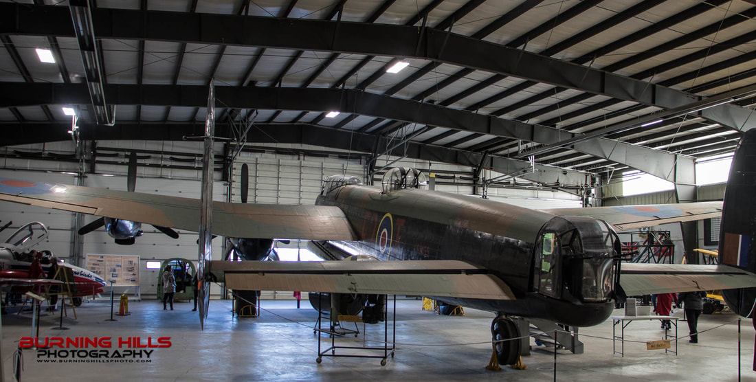
The Lancaster fills the hanger from end to end in Bomber Command in Nanton.

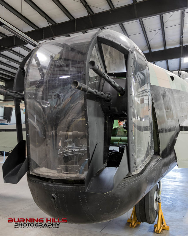
​​Two things stood out for me see the Lancaster in person.  In the play, Hank mentioned that the tail gunner was the most isolated member of the seven-man crew.  Stepping into the Lancaster this was not hard to see.  You would need to climb over what was essentially the rear wing a to get to your post and you would be exposed to the elements the whole time you where there.  There are even two little door that would block you off from the rest of the crew.  It’s easy to see that these plans were not in any way design for human comfort.  For as large as they were, there is not a lot of space inside and the tail gunner was cramped at the back, completely exposed to an attack from the back.


Picture
The skies can be a cold place.  Open to the elements the tail gunner could see temperatures of -40C

​The second thing that struct me was something else that Hank said in the play.  He said that they left out all the armor on the plane so that it could carry it's massive bomb payload.  Again, seeing this in person made me realized how exposed the whole crew really was.  The body of the plane is just thin sheet metal, not much thicker than what you would see on your average aluminum canoe.  I’m pretty sure that any gun larger than a pellet gun would have no problem penetrating this thin skin.  And man, that must have been load inside.  Anyone who has ridden on a turboprop will know how loud it can be if your seated close to that engine even with the insulated walls.  Now think of having four 1620 HP V12 Rolls Royce engines roaring beside you with nothing but sheet metal between you that raw power.
​


Picture
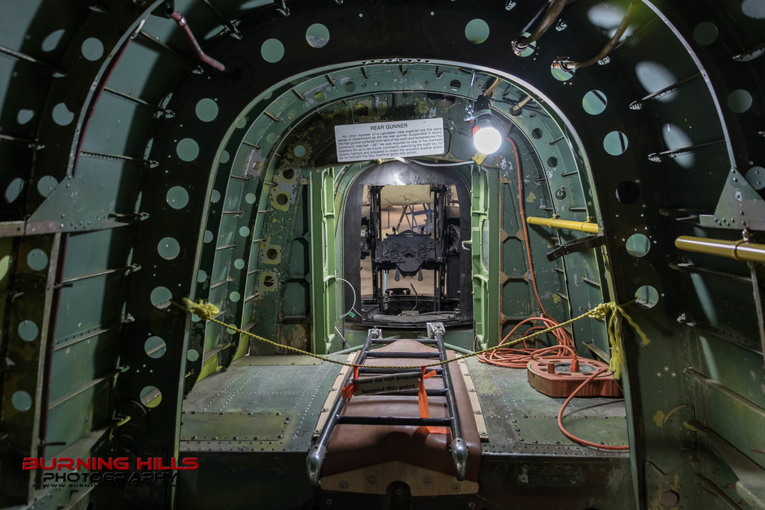
This is looking back at the Tail Gunners post.  The ladder is on top of the rear wing assembly.
Picture
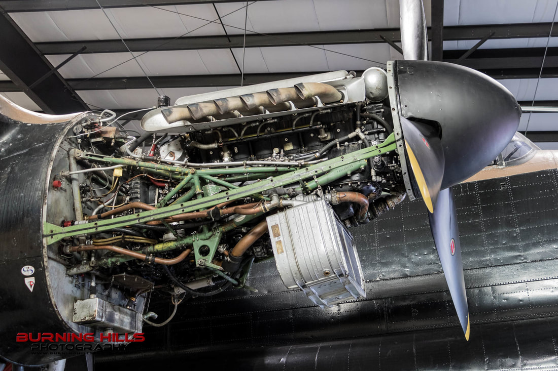
I'm always amazed when I see "old technology". 1620 HP V12 Roles Royce

Least We Forget!

Check out the Bomber Command web site.
Bomber Command
0 Comments

A Vacation in Four Parts - Act II

9/4/2015

1 Comment

 
It’s been a while since Act I, so I think I’ll give you a short recap.  Act I of our summer vacation had us make the trek from Calgary down to the Crowsnest Pass then West to the BC Kootneys.  We spent a couple days with family around Nelson and then a couple more days finding a new family at Toad Rock Motorcycle Campground.  We then had to make a bee-line for home to handle some personal business.  After a couple days of hanging at the homestead it was time to hit the road once again.  OK, that should get you up to speed.

Act II - Part 1

Picture
This is Highway 532, connecting Highway 22 to Highway 40
For Act II of our vacation we wanted to try something a bit new; camping off the motorcycle.  The challenge here is to fit two people, a tent, sleeping bags, clothes, food, etcetera, etcetera, etcetera all onto one dual sport bike, without ending up weighing as much as those Harley riders (the bikes not the people).  It was a challenge but in the end not bad; you just need to have the discipline to say “no I don’t really need that” a few dozen times.

Act I of our vacation ended up being almost all on pavement, something that needed to be corrected for Act II.  I had always wanted to see the southern portion of Highway 40.  Many of you will know Highway 40 as the road that takes you from the Trans-Canada Highway south into Kananaskis Country, one of the most popular camping and hiking areas in southern Alberta.  However, you may not realize Highway 40 goes all the way to Crowsnest Pass.  This southern leg is all gravel but well maintained.  There are campsites all along and we checked out a few of them for future reference.  You do notice a distinct difference in these campsites.  There are less big trailers, although still plenty, the sites are less crowded and, things seem to be more laid back and quiet.  Yes, this is a perfect area to recharge and recoup.  Did I mention the quiet?
Picture
A fully loaded bike
Picture
Our route for the day took us south west  to Okotoks, Black Diamond and Long View.  South of Long View the fun really started because this is where the gravel started.  We took the 532 connector to Highway 40 which is an amazing ride on its own.  This was also the most challenging part of the trip to ride.  You go through a bit of a pass along this highway and near the top we had one section that had a lot of golf ball sized rocks which tend to push the loaded bike around a lot but, we got past that without incident.  The payoff for this little bit of adventure was beautiful vistas of the foothills and the mountains along with a herd of mountain sheep that we shared the road with.  They were in no rush to clear off the road but, we were OK with sharing.
Picture
How often do you get mooned by a Big Horned Mountain Sheep
We ended up at the last camp site before Crowsnest Pass which is Racehorse Creek.  We found a very nice site within view (and sound) of Vicary Creek.  There’s nothing like falling asleep to the sound of a creek flow past your tent site. 
Picture
Racehorse Creek is only about twenty minutes from Coleman in the Crowsnest Pass.  As it turns out Highway 40 ends pretty much at one of our favorite café’s, the Cinnamon Bear.  After setting up our camp site I set out for a solo ride into Coleman to get some needed supplies (Beer, wine).  This gave me a chance to enjoy the gravel road.  With a much lighter bike I was able to ride much of the road standing up on my pegs.  This is before I took my off road training course, but that is a story for another day.
Picture
Vicary Creek provided ambience as well a cooler for our beer
Picture
Peek-A-Boo
Back at camp we heated some chili for our supper and shared a bottle of wine.  We had bought a couple of bundles of wood from the passing campsite host which I managed to chop up with my tiny backpacking axe.  It’s interesting that less than an hour away, just across the border, BC was under a complete fire ban.  But here we had the privilege of enjoying a camp fire as the night wandered away.
Picture
One of the real joys of camping is camp food. Somehow it always tastes better when cooked on an open fire
Picture
Some of our next door neighbours
The next day we saddled up once again but this time with no gear to haul and went off to do a little exploring.  We ended up at Chinook Lake (after once again stopping at  the Cinnamon Bear for a second breakfast).  Here we got out of our gear and had a pleasant hike around the lake, taking in the sites of plants, flowers, bugs and butterflies all with the backdrop of Crowsnest Mountain.
Picture
Crowsnest Mountain, always majestic!
We made our way back to our campsite but not before stopping for another bottle of wine and more importantly, a big rib steak for supper.  There is something about a steak cooked on an open fire that just can’t be duplicated in any restaurant.  The key to a good campfire steak is to take your time to prepare your fire.  Your need to build up a nice size fire and then let it burn down till you have a good pile of hot coals.  If all goes well, you end up with a nice medium rare steak that just can’t be beat and we got just that in deed.
Picture
Half way around Chinook Lake
Picture
Picture

Act II - Part 2

The morning came slowly as we enjoyed a cup of coffee and then packed our headquarters back onto the bike.  After a quick stop for breakfast once again at the Cinnamon Bear (do you see a pattern here?), it was west into BC along the now very familiar Highway 3.  We made our way past Cranbrook to the small resort town of Kimberly.  I’ve wanted to return to Kimberly for many years but never have been able to make it work till now.  I visited my sister here many years ago with my parents on one of our very few family vacations.  I was only 15 and my sister was just married and living in Kimberly.  What I remember most is the old Bavarian style town site and I was looking forward to seeing it again after all these years.  I was sad to find out that they are no longer actively promoting the Bavarian roots of the town and much of this has slipped away into the past.  There are still a couple of Bavarian restaurants one of which is shut down due to a fire but it sounds likes they will rebuild.  One thing that they have decided to keep is the giant cuckoo clock at the center of the “Platzl”.  This is in fact Canada’s largest fee standing cuckoo clock.  All in all I was a bit sad to see the state of Kimberly which seems to have fallen on hard times.  Downtown had all kinds of places closed and for sale and just didn’t seem to have the energy that you expect from a tourist town.
Picture
Our lovely hotel, downtown Kimberley
After spending two nights crawling into a tent and sleeping on the ground, we were both looking forward to a real bed.  As it turns out we found a gem in the Chateau Kimberley Hotel.  Chateau Kimberley is at the edge of the Platzl and is relatively new hotel in a fully renovated historic building. They are only open in the summer which is a bit odd as Kimberley is basically a ski town and the high season is winter.  The walls of the hotel are all filled with artwork from local artists and the thinking is that this doesn’t mix well with the normal ski crowd.  Our room was pretty amazing.  Very spacious with a king size bed and our own Keurig coffee maker meant we were in heaven.  To top it off they let us park the bike in a little alcove just outside our window.  Preferred parking for the bike is always a bonus!
Picture
Giant cuckoo clock on the "Platz" downtown Kimberley
Picture
The pizza oven at Stone Fire
At night life on the Platzl seems to pick up a little.  Much if this seemed to be centered around two popular restaurants.  We managed to try both.   We had pizza for lunch at Stone Fire, which was amazing, and we had a late supper (after an afternoon nap) at the Pedal and Tap.  This place is bicycle themed and they managed to work that theme in many creative ways.  From the pedal coat hangers to the bicycles in the fence, it was all very cool.  Oh the food was also very good.  (If you every find yourself here you must try the Muck Fries).
Picture
Coat Hangers at the Pedal & Tap
Picture
Interesting Ride
From Kimberley we decide that we had enough of Highway 3 and we instead made our way home north to Golden and then west along the Trans-Canada Home.  The Trans Canada is never my first choice but when you’re going through the mountains sometime the options are a bit limited. The hoodoos around Dutch Creek, just south of Fairmont Hot Springs are pretty incredible.  This is another area that is relatively close to home and yet we never seem to find the time to explore it.  So many places, so little time.
Picture
Hoodoos south of Fairmont Hot Springs
And so our little summer vacation draws to a close.  It seems for all the miles of road travel on the motorcycle we always find a new roads to try and few that we have to leave for “the next time”.  Some of these we will give us reason to return to an area and some will fade into the collection of roads not taken. 

Till next time, Happy Trails.

Picture
1 Comment

A Vacation in Four Parts - Act I

7/25/2015

1 Comment

 
Picture

Summer brings the need for vacation and in my opinion the best way to enjoy some extended time off is a tour on two wheels.  My wife (Sheila) and I had two weeks off but we needed to be back in Calgary for both Thursdays so we had to work this into our plans.  This made us split our plans in two and as it turns out, we had two distinct parts for each half of our vacation.


Act I - Part I

We had a leisurely start on a Friday morning.  We headed south-west of Calgary past High River and Nanton, then across to Highway 22 and all the way down to Crowsnest Pass.  Highway 22 is not my favorite highway but options are limited to go west from Calgary.  It’s often very windy and heavily traveled, but this morning it was a joy.  No wind and light traffic allowed us to enjoy the mountain views as they rolled by. 

A few years back we discovered a little café in Crowsnest Pass called the Cinnamon Bear.  Since then we have been unable to drive by without stopping in.  Fresh soup, baking, coffee and cinnamon buns make this a great place to take a break from the road and this morning was no different.  Fresh scones, chili and coffee provided fuel for the rest of our days travel.

As we continued west into BC, the temperature steadily rose.  By the time we got near our destination of Creston BC, the temperature gauge on the motorcycle was reading 34C.  In full motorcycle gear this is simply hot.  As we passed through Cranbrook, Sheila let me know it was time for a break.  Having traveled this road a few times I knew of a nice rest stop by a creek was coming up, but in the heat it seemed to take forever to reach it.  When we finally got there we quickly got out of all out gear and had a much needed cool down in the clear cool water of the creek.  Refreshed we made our final run for the day to Creston. 
Picture
Cooling off in a mountain creek
The next day was just a short ride but the route was new for us.  From Creston we rode west to Salmo and then north to Castlegar and on to our final destination for this part of our trip; near Nelson BC.  Clear skies and light traffic made this a most enjoyable ride.  Mountain views and road side diversions added to the experience.  We ended our travels for the day with a little excitement.  We were staying with some relatives and their driveway is one of the steepest that I have had the pleasure of riding up.  As we were coming up the steepest part I could just feel the front wheel lift off the gravel and then seconds later, land softly as we stopped for the day.   

Picture
Once we got to Nelson we had a no ride day and we decided to spend part of it climbing to the top of Pulpit Rock in Nelson.  At 1.8 km this is not a long hike but with a 300 meter elevation gain it is a challenge.  The reward for the effort is an amazing view of Nelson and the mountains that surround it. 
Picture
Nelson from Pulpit Rock

Act I - Part II

Picture
Picture
Toad Rock is also hosting a OAA Class is August that I will be taking
From the family visit we moved down the road a short way to Toad Rock Motorcycle Campground only to discover a new family.  Toad Rock is a campground that really needs to be experienced to understand but I will try to describe it as best I can.  The heart and soul of Toad Rock is Mary Laird.  Before Toad Rock was a campground, it was Mary’s home.  When the campground opened in 2004 Mary wasn’t so much adding a business to her home as she was expanding her home.  Everyone knows and has the utmost respect for Mary and the way she runs the campground.  Everything is on the honour system. From the coffee in the morning to the beer at night to your camping fees, it’s all assumed you will do the right thing and it all works. 

Picture
Before Toad Rock, the Campground, there was Toad Rock, well, the rock
As you ride into Toad Rock for the first time you may not be all that impressed.  The grounds are kind of junky, the cabins look a little rustic and it’s filled with bikers of all sorts.  But, with a closer look you will find that what looked like junk is subtle jokes for you to discover.  The cabins are clean and comfortable with freshly laundered sheets.  Towels  & coolers are provided for those who might need them; items that biker are not likely to carry.  But the real gem is the people that choose to make Toad Rock a stop on their travels, many of which return year after year.  There’s a real felling of community.  I can’t quite put my finger on it but I think there is a real lesson that the rest of the world can take from Toad Rock.  Again, it all just works.
Picture
Hidden gems like this little guy can be found all over Toad Rock. I'm sure that every one has a story.
Picture
Our little home for three nights.
Toad Rock was our home for the next three nights and it provided a great home base to explore some of the nearby attractions, like the town of Crawford Bay which we had visited in the past and the town of Kaslo which we had been through but never visited before.  One of the highlights of Kaslo was touring the S.S. Moyie, the oldest in tack paddle wheel stern wheeler in the world.  Since being decommissioned in 1957, the people of Kaslo have done good by the old gal, preserving this piece of history in fine fashion.
Picture
The S.S. Moyie. The oldest in tact Stern Wheeler in the world

 We ended Act I of our vacation with a 600km dash home.  We were up early to catch the first ferry of the day at 6:30AM.  From there it was back down to Creston and the back tracking pretty much the same way we had come.  With only a short lunch break in Fernie BC we managed to be back home at 3PM.  And with that, we started our short intermission.  A few days at home to kick back and get things that needed doing done and forget the rest.  Act II started on the Sunday but you will have to wait a short while to hear about that story.
1 Comment

A Different Pace

6/7/2015

2 Comments

 
Picture
I recently had the opportunity to do some off road riding in what for me was a large group.  This was a different experience as most of my riding is just me with my lovely wife hanging on the back.  It was a great experience, one that I hope to repeat in the near future.  My riding style as a solo rider is much different as I can push myself more while still riding within my limits.  Being up on the pegs for loose gravel lowers your center of gravity and makes it much easier to control your motorcycle at speed as the gravel demands that it takes its part in controlling your ride.  The group dynamic is also much different than riding as a solo pair (is solo pair an oxymoron?).  When you get a group of riders together most are there for one reason; they are there to ride.  They love being off the beaten path, seeing the world wiz by as they try to merge man (or woman) and machine as one.  One can hardly blame them; it is an absolute blast.
Picture
This however is not my usual mode of travel.  Ever since I started riding again, my wife Sheila has been riding behind me about 95% of the time.  This forces some changes in riding style, but gently nudges changes to a more relaxed style as well.  Just having two people on the bike means that the handling will be different.  Getting up on the pegs still works but is a bit more awkward, so I end up sitting a lot more which means the gravel demands that it takes a little more control of the ride.  The gravel always wants it their way.  Most significant for me is that now I have to think about the safety of two people not just me.  Like most things in life, there is a certain amount of risk that needs to be accepted.  You control what you can and, accept the rest.

All that said I love riding two up with Sheila, and she loves being my co-pilot.  We operate at a different pace than the rest of the world when we do this.  We find our own off the beaten path roads and enjoy every moment of it.  With this in mind Sheila and I set off one Saturday morning with a simple plan.  I wanted to show her a little bit of the roads I had taken with the group ride a few weeks earlier.  The whole loop would have been too much as our pace is much slower.  One thing about riding in a big group is that you can’t stop and take a picture (or twenty) every time you see something neat.  With just the two of us, this is not a problem.
Picture
We headed out west and then south of Calgary.  At Black Diamond we were forced to do a little detour as the police had blocked off the road for the annual parade.  No big deal.  A short detour through Turner Valley had us back on track past Longview and finally on to the first destination for this ride which was the Williams Coulee road. With the group just a few weeks back, I never got the chance to drink in all the beauty of this road.  I could now stop when I wanted, sometimes only driving half a mile between photo ops.  Sometimes we got off the bike and wandered around, other times I would just pull the camera from my tank bag for a few quick shots.  Had I tried this with the group I would have either been left alone in the dust or lynched and left at the side of the road.

Picture
We continued on to the end of Williams Coulee Road and then turned back towards Calgary but on random roads that had their own little adventures to discover.  This included one that required us to navigate a small herd of cattle that didn’t seem to want to give it up.  We actually had to do this twice as the road ended in a farm but this is all a part of the road less traveled.  There was also a stop for lunch, a short visit with my in-laws and a diversion to Carseland to avoid having to get onto a highway too soon.  Finally we set our sights on home.  A good day riding for our team of two.

Picture
Our style of riding is not for everyone, but it works for us.  I look forward to my next opportunity to ride solo with a group again, but I know my best rides will always be with my wife on the back seat beside me (another oxymoron, but you get the picture).  We often set out without any plans except to enjoy the day and this we do.  Sometimes we have a destination, sometimes only a direction, sometimes not even that.  We operate at a different pace, but it works for us. 

Picture
Check out the map!
For some reason my interactive map will not work with the Blog post, but if you want to see some details of our travel on this day, click
here
2 Comments

Wander With Me

5/4/2015

0 Comments

 
I invite you to wander with me.  No one can truly experience life from any perspective but their own, but I will attempt to give you a little insight in how I like to explore the world around me.  For me every wander is a little different; I like to find new places and new roads.  Sometimes I get lucky and the day I’m about to describe is a good example.
Picture
My wandering route for the day. Calgary is just off to the bottom right of the map


This wander started the night before, exploring Google maps in the general area I planned to go.  I found a road that looked to have some promise.  How did I determine this you might ask?  Well, it had a few things going for it, it was off the beaten path, it was winding road and it was surrounded my ponds and lakes. This had to be a winner.

I got up early, before rush hour hit its peak and made my way from the South-East to the North-West of the city and beyond.  I had my GPS, my map book and a plan in my head and all three needed to work together.  Before looking for my magical winding road, I thought I’d make a stop at Big Hill Springs Park.  The falls here are always pretty but it seemed almost devoid of wildlife this morning except for a couple ducks that didn’t want any part of me taking their picture.  The sound of the running water was as beautiful as the waterfalls themselves.  This is a sound that has a way of calming the mind for me like no other.  I remember thinking you can’t bottle that sound, you have to be there.  One other person was in the park enjoying the calm; he had found a quite spot across the water and it appeared he was doing his morning devotional.  Can’t think of a better spot to try and connect to a greater being.

Picture
Now it was time to back track and find my road.  The Mustang was none too happy about the gravel but got over it.  I was rewarded a few minutes later.  I had slowed down and opened my window to take in the sights and sounds of the morning, when I spotted a dark area at the bottom of a hill in a marshy pond.  What I had found was moose and he also had found me.  We stared at each other for a while.  I managed a few pictures and try to get a better angle but as I walked down the road something spooked him and he splashed away.  I walk down the road a ways and found him once more before he ran off for good.  Moose are cool!
Picture
I explored my road further and found many ducks as one would expect but also found a lot of swans.  All these were too shy for me to get too close, but I enjoyed it all the same.  The road followed one of the narrow lakes and I managed to follow a few of the ducks and swans as they made their way along it.  One other truck passed; rush hour on my road came and went in a moment.

Picture
At the end of my road I thought I’d check out another place I that I have returned to many times and that is the little village of Dogpound.  The GPS wanted me to loop around but instead I decided to do a U-turn so I could experience my road one more time.  I was wondering if I would see the moose again but it was not to be.  There really is not much in Dogpound but it is in a pretty valley and it was a direction to go in.  Along the way the landscape changed from the marshy ponds and lakes to more farmland.  On many of the fences you will find birdhouses that other bird lovers have put in place.  It was here were I found one of the most beautiful birds that have seen, the mountain blue bird.  That deep iridescent blue like the sound of the water falls earlier in the day cannot be contained in a picture or any other artificial means.

Picture
Mountain Bluebirds, Female on the left, male on the right
From Dogpound, I started to make my way in the general direction of home, with no need to rush along.  A general direction of south east found me some more back roads to explore.   Some ended up as dead ends but at least one had a final gift to offer.  I had found a road that divided another two long lakes and I spotted more ducks, geese and swans.  I once more got out of the car to see and capture what I could on the camera.  I then spotted a great blue heron; one last reward for the road less travelled.
Picture
Great Blue Heron, racing by some swans
After this my wandering for the day was done.  My reward was a few good pictures among the 200 plus that I had snapped, the knowledge of a few new spots to return too, and a relief from the stresses of life.  Not all my wanders find and many wonders as I found this morning, but they all have their reward.  Thanks for coming along; keep wandering and the wonder will show itself.

0 Comments

Bonaire - Winds of Change

4/17/2015

3 Comments

 
Picture
Sunset from the deck just outside our bedroom.
Sheila and I found ourselves back in Bonaire for the fourth time, but this time after a five year hiatus.  Many things are the same, but much has changed as well.  The sun is still warm, the water still blue and the reef still is teaming with the aquatic life that draws so many to the tiny island.  Bonaire however seems to being going through a mini revolution.  In 2010 Netherland Antilles, (Aruba, Bonaire & Curacao) was officially dissolved; the ABC islands are no more.  Aruba and Curacao decided to go their own way and become distinct constituent counties (Still part of the Kingdom of the Netherlands but countries in their own right).  Bonaire decided to take a slightly different path and became a special municipality of Netherland proper; the simplest expiation is to say that Bonaire is now considered a city in the Netherlands.  If you really want to understand the intricacies that are the Netherlands check out this awesome video:

One of the more obvious changes in Bonaire is the currency.  When we were last there in 2010, Bonaire was still using the Dutch Guilder for currency.  Ironically this was much longer than the Guilder was used in the Netherlands proper which changed to the Euro in 2002.  Since using the Euro in the Caribbean makes little sense, Bonaire, like many other countries, has simply adopted the US dollar as its currency.  Convenient except for the fact that the Canadian dollar is very low comparatively right now; small price to pay for borrowing paradise.

The closer ties to the Netherlands have brought a lot of positive change to the island.  It would appear that the motherland is providing much needed infrastructure money, which had been lacking in past years.  In the past, the potholes in the roads grew from year to year, building renovations were halted and never restarted and many vehicles were on the verge of falling apart due to the rust caused by the salty air environment.  But now potholes are being fixed, new roads are being built to Netherland standards and even the rental companies have a fleet of shiny new trucks to haul your dive gear around.  Even day to day shopping has improved, with many more modern looking options for groceries and other needs.  But in my opinion, the most dramatic change has been to the eastern coast line.  The east coast is on the windward side of the island and therefore collects all the junk that people throw into the ocean.  This in the past has been a very sad sight.  Piles of garbage littered the coast as the waves deposit everything from pop bottles to flip flops to toilet seats on the rocky shoreline.  The garbage still keeps coming as we still have not learned not to use the ocean as a garbage dump.  The people of Bonaire however have made a huge effort to clean up this coast.  The eastern coast line has been transformed from a place which you couldn’t help but feel sad, to a place where you can really appreciate the raw power and beauty of the ocean with just enough of reminder of the work that must continue to clean up our environment.
Picture
This ruin on the South-East coast, shows the effort that the people of Bonaire have put into cleaning up the island. I took the picture on the bottom left, back in 2010 to show the trash that was littered all over the coast. Fast-forward to 2015 and its all gone. Awesome!
This trip was different in other ways as well; this trip was different in the how and when.  The when was different because in the past we have gone in November, which is the rainy season which runs about from October to January.  Bonaire is essentially a desert island so even in rainy season the amount of rain varies a lot, but in a week’s span you’re sure to get some rain.  In March however, the rainy season has past and the lack of rain brings the brown grass and dead leaves as well as a variety of local vegetation fighting for its survival.  The many varieties of Cacti however thrive in this environment and we were witness to more than a few in full bloom.  Life finds a way.

Picture
The other change in this trip was the how.  In the past we have always gone in a relatively large group, 12-18 people, with the primary purpose of diving, which is a great goal to have.  This time however it was just us and our gracious hosts who now make Bonaire their part time home.  Being the guest of a “newly minted local”, has a great advantage in that they have found the hidden treasures that most tourists only hope to happen upon.  Our host also introduced us to a few of the others that make Bonaire home.  Making a living on a remote desert island is not an easy task but for those few that are driven enough, a way can be found if you’re willing to adapt and accept what the island offers you.  I offer you two examples that you can check out for yourself if you ever decide to make the journey. 

First, for snorkel & photo tours, check out H2O Visions.  Brenda is the owner operator and a fellow Canadian. She will be sure to find you the best that Bonaire has to offer.  For an eventful day out on the island ask about a "snack tour"

Second, check out Phish Phaktory for a truly unique gift or just to get some sewing done.  Eunan & Suus run Phish Phaktory out of their home to repurpose and repair items that would otherwise end up in some landfill or worse, in the ocean.  The results are both unique and artful and have the quality that you rarely find in our disposable world.  Eunan & Suus are a great example of how people can adapt and endure and make the best out of the path that life puts out in front of us all.

PictureOne of many Pelicans that we found on the west side of Washington Slagbaai National Park, fishing the ocean shore from the cliffs.
I did get a chance to dive as is to be expected and it was as wonderful as I remember. But we also had a chance to see many other things that Bonaire has to offer.  Washington Slagbaai National Park takes up most of the northern section of the island.  There are two options to drive through the park, a long route and a short route.  Either will give you a change to see some of the diverse landscape and wildlife with very little in the way of crowds.  There are beaches, hiking trails, wild birds, donkeys, goats, lizards, iguanas and yes, a few dive and snorkel sites as well.  It tends to be a full day excursion as the road is narrow a rough and there are lots of areas to explore. 

Picture
We have been to the park before but something that we had not done before  is to kayak the mangroves.  The northern shores of Lac Bay are filled with these saline loving shrubs.  Taking a kayak through them is a great way to see a different side of the island and snorkelling through them gives you a chance to see a wide variety of fish and jellyfish in a unique environment.  


Bonaire appears to have a bright future.  The blue waters and the pristine reef will keep the tourist dollars rolling in.  The tourists may bring the dollars, but the real change comes from the locals; both native and adopted.  Bonaire is in good hands.
Picture
3 Comments

Bumbling to Bonaire

3/26/2015

1 Comment

 
Picture

The most common question I get when I tell people I'm going to Bonaire, is "Where?"  Scuba divers know about Bonaire but most other people do not.  There is a good reason for this because while the diving is spectacular, it doesn't have a lot of sandy beaches to draw the normal vacation crowd.  People go to Bonaire to dive.  There is however other things to see and do on the island, just not a lot of people seek these out, which is fine by me as I enjoy being away from the crowds.  If you follow along for the next while, I hope I can share some of these with you.

Bonaire is part of the Dutch Caribbean, along with its sister island of Aruba and Curacao, sometimes referred  to the ABC islands.  Situated in the southern region of the Caribbean, Bonaire is less than 100 miles north of Venezuela.  


Why is Bonaire so popular with divers, you might ask?  Simply put it has some of the world's best diving.  It also has some of the most accessible diving,  there are more that 50 dive sites that you can simple drive up to, put on you gear and walk in; no dive boat required. 

This will be our forth trip to this lovely little island.  This time will be to celebrate my 50th birthday.  Our winter in Calgary has been pretty mild but that doesn't mean I'm not longing to spend a week in shorts, enjoy some warm water diving and drink a cold beer on a warm deck watching the sunset on the blue of the Caribbean Sea.

Stay tuned...
Picture
1 Comment

    Authors

    Ed and Sheila Hildebrandt 

    Archives

    November 2017
    September 2015
    July 2015
    June 2015
    May 2015
    April 2015
    March 2015

    Categories

    All
    Alberta
    Bonaire
    Motocycle
    Travel

    RSS Feed

All Images © Copyright 2018
Burning Hills Photography
To purchase photos, please email Ed
Picture